NEW! The Gist (APR-24) | E-BOOKS |
(IGP) GS Paper 1 - India & World Geography - "Africa"
Integrated Guidance Programme of General Studies for IAS (Pre)
Subject - India & World Geography
Chapter : Africa
Africa:
- Size : Second largest continent after Asia and nine times the size of India.
-
Situation : Situated to the south of Europe and south west of Asia. It is bound by the Meditarranean Sea in the north, the Atlantic Ocean in the west and southwest, the Indian Ocean in the east and the Red Sea in the northest. Africa belongs to all the four hemispheres and bulk of the continent lies in tropics. It is joined to Asia by the narrow isthmus of Suez and separated from Eurasia at three diffirent points (Strait of Gibraltar, Suez Canal and Strait of Bab-el-Mandeb). The only continent which is crossed by Tropic of Cancer, Equator and Tropic of Capricorn.
Principal Countries:
-
Algeria, Angola, Benin, Botswana, Burkina Faso, Burundi, Cameron, Cape Verde, Central African Republic, Chad, Comoros, Congo, Cote D’lvoire, Djibouti, Egypt, Equatorial Guinea, Eritrea, Ethiopia, Gabon, Gambia, Ghana, Guinea, Guinea Bissau, Kenya, Lesotho, Liberia, Libya, Madagascar, Malawi, Mali, Mauritania, Mauritius.
For Detail Description, Analysis and More MCQs of the Chapter Buy this Study Notes:

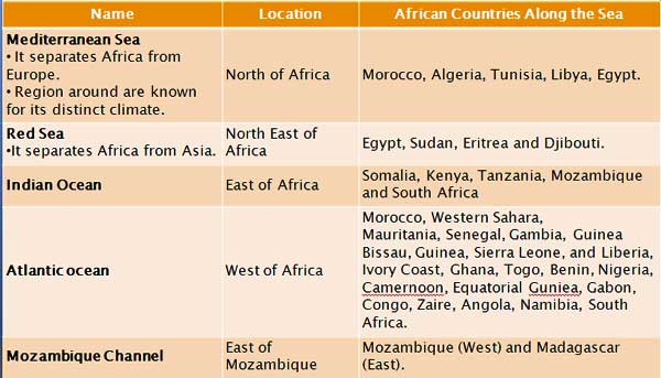
Important Seas / Ocean Channels around Africa:
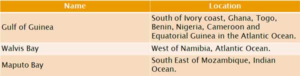
Important Gulfs and Bays:
RIFT VALLEY OF AFRICA:
-
It stretches northwards through Zambia, Malawi (L. Nayasa), Tanzania (L. Tanganyika), Kenya and Ethiopia and extends along the Red sea to Israel and Jordan for about 5,000 km. Most of the lakes fill parts of rift valleys and therefore are long, narrow and deep.
SUEZ CANAL:
- Connects the Mediterranean Sea with the Gulf of Suez and Red Sea across the low Isthmus of Suez.
- Total length of canal is 172 Km (107 miles.)
- Sea ports of Port Said on the Mediterranean and Suez on the Gulf of Suez are situated at the opposites ends of the canal.
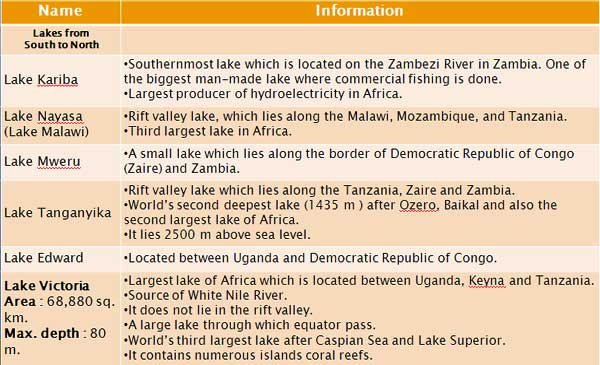
Important Lakes:
Important Rivers:
Nile
Source : Blue Nile : Lake Tana (Ethiopian Highlands)
White Nile : Lake Victoria
Outflow : Arcuate
- The White and Blue Nile meet at Khartoum (Sudan) to form the Nile.
- Longest river in the world, life blood of Egypt.
Dams
- Owen Dam near the Owen falls, on the White Nile, where it leaves Lake Victoria.
- Sennar Dam on the Blue Nile in Sudan.
- Aswan Dam on the Nile in Egypt—Controls the flow of the greate river.
Zaire Or Congo
- Confluence of Lualoba and Luapula River.
- Joins the Atlantic Ocean near the port of Matadi.
- Carriers the largest amount of water among all the rivers of Africa.
- Navigable only in part because it has numerous waterfalls and rapids (small waterfalls).
- It cuts equator twice.
- The Kasai and the Oubangi are the main tributaries of Zaire.
- Half the world’s supply of industrial diamonds comes from the alluvial deposits of the Kasai river.
- Stanley Fall and Living Stone Fall are on the Zaire River.
- Inga Dam is located on the Zaire River.
- Cities located : Brazzaville, Kinshasa, Matadi and Boma.
- Country’s only outlet to the ocean.
Niger River
- Source : Guinea
- Outflow : Gulf of Guinea
- It starts in Sierra Leone flow north-east through guine and Mali turns south-eastwards, across West Nigeria to Lokoja where it is joined by its main tributary, the Benue.
- The third longest river in Africa.
- Port Harcourt of Nigeria is located on the Niger Delta.
ZAMBEZI River
- Source : Katanga Plateau
- Outflow : Mozambique Channel (Indian Ocean
- Its original name in the local language means The smoke that thunders’.
- The Zambezi’s course includes the spectacular Victoria falls, one of the largest in the world and Lake Kariba, Kariba Dam is built on it.
- Coborra Bassa Dam in Mozambique is also located on the Zambezi River.
- It is also a natural political boundary between Zambia and Zimbabwe.
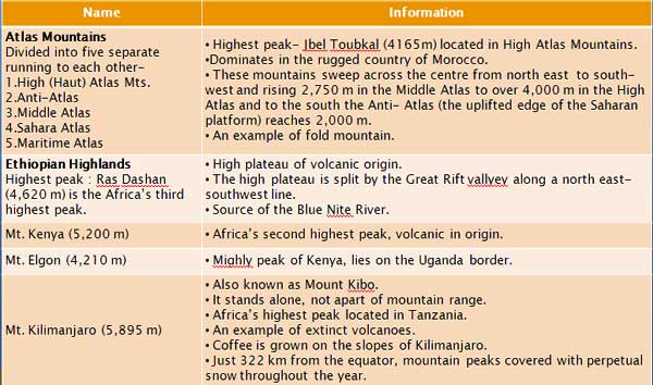
Important Mountains and Plateaus:
Deserts:

For Detail Description, Analysis and More MCQs of the Chapter Buy this Study Notes: